Decoding Aviation Meteorology: Understanding Thunderstorms
Learning about thunderstorms is critical for aviation professionals, including pilots, cabin crew, air traffic controllers (ATC), and other aviation personnel, because thunderstorms pose significant risks to aviation safety.
These weather systems, characterized by cumulonimbus (CB) clouds, can produce severe turbulence, lightning strikes, hail, and reduced visibility, all of which endanger aircraft and passengers.
The presence of microbursts and strong wind shears can lead to loss of control during takeoff and landing, making navigation around these hazardous weather systems essential. Understanding the behavior and characteristics of different types of thunderstorms, such as single-cell, multi-cell, and supercell storms, helps aviation professionals make informed decisions to ensure safety.
Experienced aviation professionals can attempt a short quiz directly on Thunderstorms to check their knowledge. Click the button below or the icon on the right-side tab to start the quiz.
What is Thunderstorm?
A thunderstorm is a weather system produced by strong convection currents. It consists of cumulonimbus (CB) clouds that cause lightning flashes, the rumbling sound of thunder, a darkened sky, sudden cool and squally winds, and sharp showers. Some thunderstorms are very violent and can cause floods, forest fires due to lightning, hail, tornadoes, waterspouts, and microbursts.
Severe thunderstorms, or TS, are those accompanied by locally damaging winds, frequent lightning, thunder, or large hail.
Typed of TS
Thunderstorms are classified as heat (or air-mass) TS, frontal TS, and mesoscale convective complex (MCC) according to their method of formation.
Frontal TS occur at a cold front and occasionally at a warm front. These are triggered by the vigorous uplift of moist air along or ahead of a cold front or sometimes in a warm front.
Frontal TS are more violent than air-mass TS and may develop at any time of day or night. Sometimes, 100 to 300 kilometers ahead of a fast-moving active cold front, a line of TS develops. This is called a squall line and causes severe weather.
An air mass thunderstorm (TS) is associated with intense heating and convergence due to low pressure. Air mass TS also occur when cold air passes over a warmer sea. These storms pop up randomly within a mass of warm, humid air. They are relatively weaker systems compared to frontal TS.
Due to intense convection, air mass TS mostly develop in the afternoons in the plains, while in valleys and hills, they may develop during the night or morning.
Mesoscale Convective Complex (MCC), In recent years, the study of satellite imagery has revealed a third mode of TS occurrence called Mesoscale Convective Complex (MCC). An MCC is a nearly circular cluster of many interacting TS over a very large area, which may be thousands of times the area of an air mass TS. New TS continually develop within an MCC, extending the life of the storm system from 6 to 24 hours.
These produce severe weather, including tornadoes and flash floods, and can cause a sudden rise in the level of rivers or streams, leading to floods. MCC are synoptic-scale systems and are common features in the USA.
Classification of Thunderstorms
- Single Cell: A single cell TS has one main updraft. Such storms are rarely severe and are due to local instability and heating in summers (heat or air mass TS). They also occur in cold fronts in winters.
- Multi-Cell Cluster: These form as clusters of storms due to convective updrafts in or near mountain ranges and strong cold fronts or troughs of low pressure.
- Multi-Cell Lines: Commonly called squall lines, they can be hundreds of kilometers long and move swiftly. They cause heavy rain, hail, lightning, very strong winds, and even isolated tornadoes.An unusually powerful squall line is called a derecho. Occasionally, squall lines also form near the outer rain band of tropical cyclones.
- Super Cell: These are large and severe storms with separate updrafts and downdrafts, and rotating updrafts (a mesocyclone). Due to powerful updrafts, they can reach the lower stratosphere. They can produce destructive tornadoes, very large hailstones (up to 10 cm in diameter), winds exceeding 130 km/h, and flash floods. Most tornadoes occur from such TS.
The presence of microbursts and strong wind shears can lead to loss of control during takeoff and landing. Pilots must navigate around these hazardous weather systems, leading to delays and rerouting, which increase fuel consumption and operational costs.
Understanding the behavior and characteristics of thunderstorms is crucial for aviation safety and efficiency, making accurate weather forecasting and real-time monitoring essential components of flight operations.
Favorable Conditions for Thunderstorm (TS) Formation
TS is an instability phenomenon. The following conditions are essential for its formation:
- Steep Lapse Rate: A lapse rate steeper than the Saturated Adiabatic Lapse Rate (SALR) throughout a layer at least 5-6 km in depth, permitting the development of clouds above the 0°C level.
- High Humidity: Adequate supply of moisture from below and high humidity aloft. If the humidity of the surrounding air is very low, the growth of the cloud is arrested due to the evaporation of the rising parcel of air.
- Trigger Action: A lifting mechanism that can produce saturation in the region of the steep lapse rate.
Triggering Mechanisms
- Insolation (Local Convection)
- Frontal Lifting
- Convergence
- Orographic Lifting
- Radiational or Katabatic Cooling
Life Cycle of a Thunderstorm
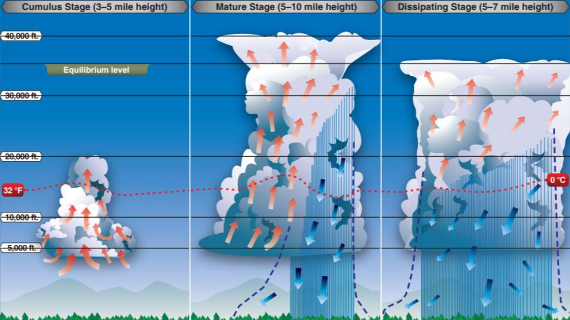
Cumulus Stage
Due to the triggering mechanism, a parcel of air is lifted, expands, and cools at the Dry Adiabatic Lapse Rate (DALR) of 9.8°C/km. Further lifting may cool it to saturation, leading to condensation and the formation of cumulus (CU) clouds. The parcel of air rises higher and higher as long as it is warmer than the surroundings.
The updrafts carry warm air upwards and sustain water drops and ice crystals formed in the cloud. The rain, snow, or hail particles keep growing inside the cloud until they become too large and heavy, falling out of the cloud as precipitation.
Inflow to the cell (called entrainment) takes place through the sides at all levels and the base of the cloud. The average life of this stage is about 15 to 20 minutes.
Mature Stage
The mature stage begins when precipitation reaches the surface. The falling precipitation drags the adjacent air and generates downdrafts. These cold downdrafts continue to descend and accelerate.
In this stage, both updrafts and downdrafts coexist. The entrained air being drier causes some of the precipitation particles to evaporate, cooling the downdraft further.
Finally, at the ground, the cold downdrafts reach as a squall. The downdrafts close to the ground spread out horizontally, and its leading edge is called the First Gust.
Since old cells dissipate and new cells form continually, TS activity may sometimes prolong. This is the most violent stage of a TS and presents serious aviation weather hazards.
Clouds Associated with Mature Stage
- Roll Cloud: An elongated cylindrical dark cloud that appears to rotate slowly about its horizontal axis. It occurs behind the First Gust but is detached from the CB. It is seldom associated with severe weather.
- Shelf Cloud: A wedge-shaped elongated cloud with a flat base. It occurs at the edge of the Gust Front and beneath and is attached to the CB. It forms due to the uplift of the warm air along the Gust Front. It is associated with severe weather.
Dissipating Stage
In this stage, only weak downdrafts exist in the cloud, mainly confined to the middle and lower levels. With no updrafts, the further growth of the cloud ceases.
In the dissipating stage of a thunderstorm (TS), the cloud top spreads to form an anvil, also called False Cirrus. Downdrafts spread across the lower portion of the cumulonimbus (CB) cloud, resulting in light rain at the ground. Gradually, the cloud dissipates.
To access the entire blog, subscribe to our premium plans today and get one step closer to your Aviation Dreams Get AviationX Plus or AviationX Pro today for all things Aviation.
Limited time Super offer on AviationX Plus Membership (50% Forever discount)