Decoding Aviation Meteorology: Understanding Vertical Motion & Clouds


In this blog post on the Aviation Meteorology Series, we will be discussing in detail about Vertical Motion & Clouds. This is a must-read for all practising and aspiring pilorts, cabin crew and all aviation professionals. and a very interesting read for all aviation professionals. We recommend reading the entire blog for comprehensive learning.
Experienced aviation professionals can attempt a short quiz directly on Vertical Motion & Clouds to check their knowledge. Click the button below or the icon on the right-side tab to start the quiz.
Vertical motion and clouds play crucial roles in aviation, impacting weather patterns, turbulence, and overall flight safety. Understanding the dynamics of vertical motion and cloud formations is essential for pilots, cabin crew, and all aviation professionals.
While horizontal motion (wind) often garners more attention, vertical motion significantly influences weather phenomena, including the formation of fog, drizzle, and various cloud types. Localized vertical motion, driven by factors like friction, terrain, and convection, can create localized weather patterns such as sea/land breezes and valley winds.
On a larger scale, vertical motion induced by pressure systems, frontal boundaries, and mountainous terrain can extend over vast distances and heights, affecting aviation operations across regions. Moreover, clouds, classified based on their form, height, and composition, provide valuable visual cues about weather conditions aloft.
Recognizing different cloud types and understanding their associated hazards is indispensable for making informed decisions during flight planning and execution.
Hence, this blog serves as a comprehensive guide for navigating the complexities of vertical motion and clouds, ensuring safe and efficient operations within the aviation industry.
The Vertical Motion
Compared to the horizontal motion of the air (wind), vertical motion is of very little magnitude, yet its importance in causing weather is no less.
The vertical motion of air in the atmosphere is significant for aviation, as it influences weather patterns, turbulence, convergence, divergence, wind shear, and more.
For aviation, frictional turbulence at low levels assumes special significance during landing and takeoff.
Types of Vertical Motion
Localized Vertical Motion: Local vertical motion is caused by friction, terrain, and convection. The occurrence of sea/land breezes, katabatic winds, valley winds, etc., is due to local vertical motion. Mostly, local vertical motions are confined to a few kilometers only, except in the case of thunderstorms.
Large Scale Vertical Motion: Large-scale vertical motion is caused by pressure systems, frontal systems, upper air troughs and ridges, and mountains. It may extend to hundreds of kilometers horizontally and to great heights. The vertical motion due to mountain waves may even extend to the upper stratosphere.
Causes

Frictional Eddies
Ground friction disrupts the smooth airflow and produces a number of small circulations called eddies. They could be horizontal, vertical, or slant. In an unstable atmosphere, these eddies grow and may ascend to about 1 km in height.
Terrain
Airflow across mountains causes air to ascend on the windward side and descend on the leeward side. These vertical motions are accentuated due to instability and are damped due to inversion. When winds are strong, mountain waves are produced on the leeward side. Eddies form on both slopes of a mountain.
Convection
Heating of the ground causes air to rise as convection cells. These are called thermal eddies or thermals. Gliders use them to their advantage.
Thermal eddies cause bumpiness and also favor the formation of convection clouds (CU and CB), in which there are strong up and down drafts.
Pressure Systems
All pressure systems, such as lows, cyclones, and anticyclones, cause a large mass of air to ascend or descend over a wide area. These generate weather and affect air operations. Such systems also cause convergence and divergence.
Frontal Zones
Fronts provide sloping surfaces along which wind rises. Along a warm frontal surface, the vertical motion is gradual over a large area.
Along a cold frontal surface, there is abrupt and sharp upward motion leading to convection, thunderstorms, and squally weather.
Wind Shear
Vertical wind shear produces strong eddies and turbulence. The clear air turbulence (CAT) associated with the jet stream is due to vertical wind shear. The effect is amplified over the mountains due to mountain waves.
Convergence and Divergence Associated with Low and High

Convergence
Convergence occurs when there is a net horizontal inflow of air into a region. The air accumulated due to convergence (called velocity convergence) causes ascent of air near the ground whereas in the upper levels, the convergence may lead to both upward and downward motion, especially below the tropopause (stratosphere being stable acts as a barrier).
Divergence
A net outflow of air is called divergence. For example, wind to the west of a station is Wly 10 kt and to the east is Wly 20 kt. In this case, less wind is entering a place and more is outflowing, hence divergence (also called velocity divergence).
In the upper air, the divergence causes subsidence. Anticyclones and ridges are associated with divergence leading to fine weather but poor visibility conditions.
Clouds

A cloud is an aggregate of visible forms of water droplets or ice particles. Cloud droplets are produced by condensation and the deposition of water vapor in the atmosphere. Deposition is the process wherein water vapor directly changes into solid ice particles.
Clouds are continuously evolving and decaying, presenting unlimited variety and forms. Recognizing and understanding various characteristics and peculiarities of clouds are essential for the safe conduct of air operations.
To fully appreciate the state of the sky, an aviator should be familiar with their classification, names, appearance, nature, and associated aviation hazards. Photographs of a few clouds are presented in this blog.
Classification
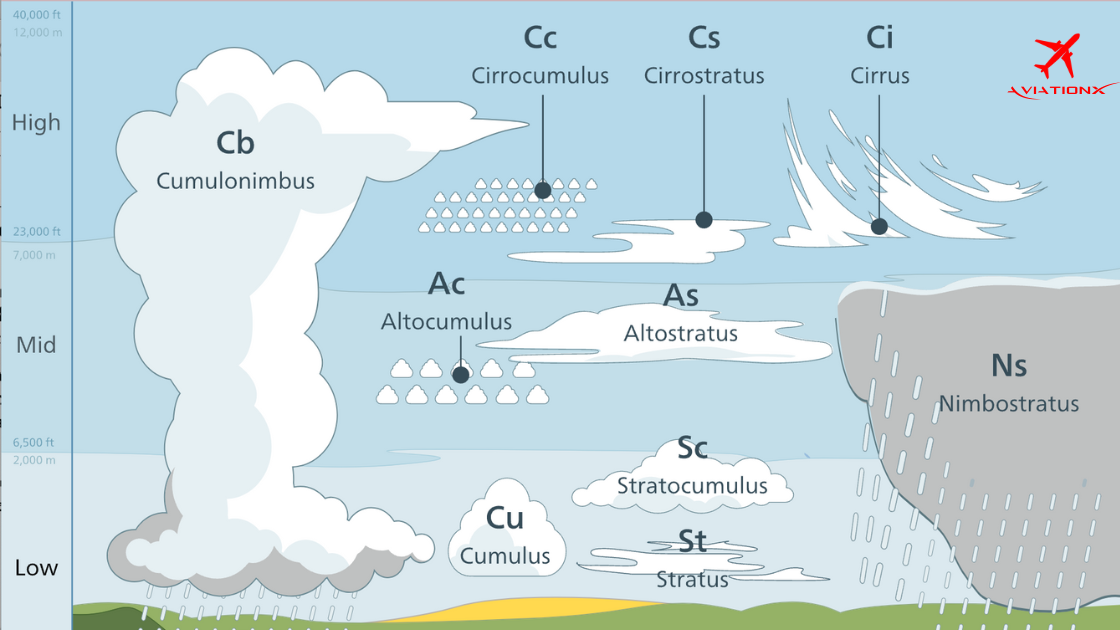
There are 10 major genera of clouds, classified based on Form and Height. By Form, they are categorized as Stratiform, Cumuliform, and Cirriform. According to Height, they are placed in three categories:
(a) High Clouds: These clouds form at a height of 6-18 km in the tropics. They consist of ice crystals, and some may cause precipitation, which remains confined to high/medium levels only. These clouds provide an advance indication of impending weather.
(b) Medium Clouds: In the tropics, they occur at about 2-8 km and contain water droplets and ice crystals. They cause snow and rain.
(c) Low Clouds: These clouds occur below 2 km and consist of water droplets or ice crystals.
To access the entire blog, subscribe to our premium plans today and get one step closer to your Aviation Dreams Get AviationX Plus or AviationX Pro today for all things Aviation.