Decoding Aviation Meteorology: Understanding Visibility & Fog

In this blog post on the Aviation Meteorology Series, we will be discussing in detail about Visibility & Fog. This is a must-read for all aspiring pilots and a very interesting read for all aviation professionals. We recommend reading the entire blog for comprehensive learning.
Experienced aviation professionals can attempt a short quiz directly on Visibility and Fog to check their knowledge. Click the button below or the icon on the right-side tab to start the quiz.
Visibility on the ground and in the air is crucial for pilots during landing and takeoff. Pilots need to identify landmarks, targets, obstacles, beacon lights, other aircraft, and runways while in flight and during approach and landing.
Poor visibility poses a significant aviation hazard. Even at airfields equipped with Instrument Landing Systems (ILS), pilots prefer better visibility conditions for safe operations.
Aeronautical visibility is defined as the greatest distance at which a black object of suitable dimensions, located near the ground, can be seen and recognized against a bright background.
Visibility reports provided by meteorological offices specify the lowest horizontal visibility at an airfield. This visibility may vary in different directions due to varying atmospheric obscurities. Additionally, it may differ from vertical and slant visibilities estimated by an aircraft while in-flight.
The estimation of visibility during the day involves assessing the runway markings and objects at predetermined distances within and around the airfield.
At night, visibility is determined by the existing lights at known distances in and around the airport, referred to as Visibility Land Marks.
Runway Visual Range (RVR)

Runway Visual Range (RVR) is the range over which an aircraft's pilot on the centerline of the runway can see the surface markings or lights indicating the runway or its centerline.
Poor Visibility Reasons
Poor visibility can result from atmospheric obscurities like smoke particles, sea spray, dust, industrial emissions, vehicular emissions, volcanic ash, etc. Weather phenomena affecting visibility include haze, dust haze, smoke haze, mist, and fog.
- Haze is a suspension of small particles like smoke, dust, water, etc., with visibility reduced to 5000 meters or less, giving the atmosphere a milky appearance.
- Dust Haze occurs when strong winds kick up dust in desert and semi-arid areas, with thicker haze during the day due to weakened winds at night. It is a summer hazard.
- Smoke Haze forms when smoke from industrial or domestic sources spreads as a haze layer, particularly during calm or very light winds and strong ground inversion.
- Mist involves the suspension of water droplets in the atmosphere, with visibility between 1000 and 5000 meters, and a relative humidity of almost 100%.
- Fog is the suspension of water droplets or ice crystals, reducing visibility to less than 1000 meters, with nearly 100% relative humidity. Fog is classified as thick, moderate, or light, resembling a cloud sitting on the ground. Fog results from the condensation of water vapor within the lower layers of air close to the ground. Condensation can occur either through the cooling of air to the dew point or by introducing moisture into the air to saturate it.
- When fog and smoke haze coexist, it is termed smog, characterized by extremely poor visibility and posing a health hazard.
- In a dust storm, visibility is reduced to 5000 meters or less. However, if the dust storm is followed by rain, visibility improves rapidly.
- Sea spray, caused by salt particles being sprayed from wave crests under favorable wind conditions, can lead to significant visibility reduction. In rare instances, a thin layer of salt may form on an aircraft's windscreen at low levels, nearly obstructing forward visibility. Salt spray can also decrease visibility during monsoons and cyclones in coastal areas.
- Visibility during precipitation depends on its intensity and drop size. In moderate rain, visibility may reduce to 1-3 km, in heavy rain or showers to less than 1000 meters, in drizzle to 3 km or less, and during snowfall, it may lower to less than 1000 meters.
The diagram below illustrates the obscuring of an aerodrome due to surface fog as an aircraft descends.
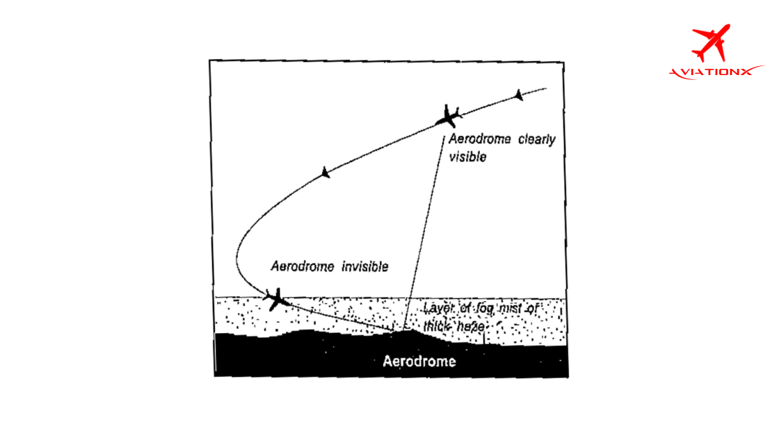
The visibility conditions range from an aerodrome being clearly visible to becoming completely invisible under the influence of dense fog.
To access the entire blog, subscribe to our premium plans today and get one step closer to your Aviation Dreams Get AviationX Plus or AviationX Pro today for all things Aviation.